NW Trails: Victoria’s Backyard Wilderness
April 20, 2015
Hiking the stunning Gowlland Range
Story and Photos by Craig Romano
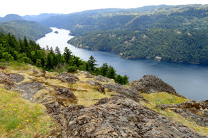
Photo at right: Finlayson Arm from Jocelyn Peak in the Gowlland Range
When Sir James Douglas established the Hudson’s Bay Company trading post, Fort Victoria in 1843, he probably had no idea that his Vancouver Island outpost would evolve into one of North America’s most charming cities.
Nor could he imagine that it would become Canada’s fittest city.
According to Statistics Canada, over one-third of Victoria’s adult population is active (nearly double the national average). How could they not be—living in such a mild climate surrounded by a stunning coastline, golden hillsides, emerald ridges and snow-capped mountains?
And how could so many of them not be into hiking when British Columbia’s capital city is within minutes to thousands of acres of provincial and regional parks harboring hundreds of miles of topnotch trails?
Let me introduce you to one of the finest hiking destinations within the Capital Regional District.
Explore Tod Provincial Park
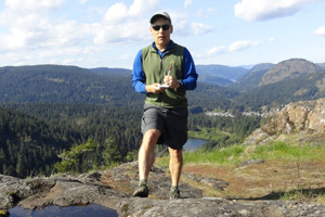
Author Craig Romano takes notes on Mount Wells; Finlayson is in the background.
If you’re like many visitors to Victoria, you have probably ventured to Butchart Gardens to stroll among its famed grounds. Yet, you probably have no idea that just across Tod Inlet from which the gardens grow is one of the largest and best hiking destinations in the region.
Here, find the sprawling Gowlland Tod Provincial Park, the largest natural area on Vancouver Island’s Saanich Peninsula. Consisting of over 3,000 acres and miles of trails, it is named after the Gowlland Range which rises more than 1,300 feet above Finlayson Arm forming a dramatic fjord and the beautiful Tod Inlet.
The range consists of a rare dry coastal old-growth Douglas fir forest punctuated by open grassy rocky knolls. The range is also home to nine “species at risk” (Canadian equivalent to endangered species).
From the McKenzie Bight Trailhead, just minutes from Butchart Gardens, you can begin a challenging and stunningly beautiful traverse of the range. Over rocky and rough terrain, follow the Timberman Trail up and over several summits including Jocelyn Hill which teeters high above the sparkling waters of Finlayson Arm.
Then savor one of the finest stretches of trail on Vancouver Island as you amble along the fjord’s edge on your way to Holmes Peak. From here you can continue along the ridge via a short road walk and pick up the trail again to hike up and over steep Mount Finlayson if you dare.
A well-known Victoria area landmark—and one of the most climbed peaks on Vancouver Island—Mount Finlayson is the scenic centerpiece of the 1,100-acre Goldstream Provincial Park.
Known as Mount Finney to the locals, Mount Finlayson is no easy ascent.
Rocky and brutally steep, most of the trail is barely a route along exposed ledges at times. This hike, despite its numbers of visitors, should only be attempted by strong hikers comfortable with scrambling.
From the 1,375-foot rocky open summit, enjoy sweeping views of the Saanich Peninsula, Victoria and a whole lot more.
You can see Mount Baker, the Olympics and on a clear day—even Mount Rainier. Many of the Gulf and San Juan islands are also visible including San Juan Island’s Mount Finlayson—named for the same Hudson’s Bay Company employee and Victoria founding father, Roderick Finlayson.
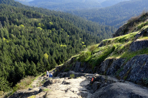
The trail up Mount Finlayson leads to sweeping views from its 1,375 foot summit.
Goldstream Provincial Park also contains a salmon-spawning river, 600-year old forest, a breathtaking waterfall named Niagara no less, historic gold mine, campground, nature center, and miles of excellent hiking trails. Consider checking out this park’s other trails on a future visit.
And if the Gowlland Range traverse is a tad too much for your liking, you may want to opt instead to do a much shorter and easier hike to a quiet cove on the Squally Reach at the mouth of the Finlayson Arm.
From the same trailhead for the Timberman Trail, follow instead the McKenzie Bight Trail. Through mature second growth steeply descend into a moist ravine coming to the Bight in less than a mile. Look for otters and eagles and enjoy exploring curved geological features in the coastline.
You can continue farther on the trail along rocky coastline passing big trees, old quarries, and favorite haunts of local divers for another .8 mile; or loop back to the trailhead via the Cascade Trail. As the name implies, you can expect to see a waterfall on the return.
The Capital Regional District contains many other fine hiking destinations as well—most just a few miles from downtown Victoria. The next time you visit, plan to see a side of Victoria that is a little more adventurous than manicured gardens and tea houses.
Getting You on Your Way
Trip Details
Distance: Full Gowlland Traverse 14 miles roundtrip with over 2,000 feet of vertical elevation.
Trailhead Directions: From Victoria or Sidney, follow BC 17A (West Saanich Road) to Wallace Drive to Willis Point Road. Then turn left onto Ross-Durrance Road, soon reaching trailhead and parking.
Notes: Dogs allowed on leash.
Contacts: BC Parks; www.env.gov.bc.ca/bcparks
Craig Romano is Trails Editor of OutdoorsNW and is the author or co-author of 13 Northwest hiking guidebooks including Day Hiking The San Juans and Gulf Islands (The Mountaineers Books), which includes detailed descriptions for over 20 hikes in the Victoria area.


