
NW Trails: Chasing Waterfalls in the Columbia River Gorge

Story and Photos by Craig Romano
It’s autumn in the Pacific Northwest which means it’s time to go chasing waterfalls!
With the return of the rainy season, thousands of rivers and creeks flowing through and down our mountains are getting recharged. And the more water they receive, the higher their cubic feet per second (CFS), resulting in more breathtaking, awesome, and spectacular waterfalls.
The Columbia River Gorge, which splits Oregon and Washington for 80 miles, is one of the best places in the country to view waterfalls. And autumn in the gorge is the best time to see them. Can you say high CFS and low HCT (that’s hikers crowding trail) on one breath?
Here are three choice cascades worth getting your boots wet.
NW Trails is sponsored by:

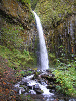
Rodney and Hardy Falls
Roundtrip: 2.2 miles
Elevation Gain: 500 feet
Green Trails Map: Bridal Veil, Ore., no. 428
Hike to a pair of dramatic waterfalls tumbling down Hamilton Mountain, one of the most recognized peaks on the Washington side of the gorge. While ascending Hamilton can be a challenge, the hike to the falls is easy and kid-friendly.
Begin in a lovely picnic area graced with structures built by the Depression era CCC. Then immediately enter a grove of large firs and start climbing. After passing through a power line swath, bear right at a junction with a trail leading to the campground. Continue climbing through attractive forest bursting with a golden understory of vine maple.
At just over a mile, come to a junction for the Hardy Falls Viewpoint. Affording not the best vista, the spur drops steeply 50 feet to a platform above the falls. Better waterfall viewings wait ahead — so don’t despair. At the next junction head left to roiling Rodney Falls. Stand mesmerized watching this 50-foot cascade thunder through a tight chasm into a punchbowl basin named “Pool of Winds.” “Pool of Mist” is more like it — and in autumn you’d be best to view it with your rain slicker on.
Latourell Falls
Roundtrip: 2.3 miles
Elevation Gain: 540 feet
Green Trails Map: Bridal Veil, Ore., no. 428
Hike a delightful loop though an emerald ravine to a pair of impressive falls roaring over steep basalt cliffs. The lower falls — immediately viewed from the trailhead — plunges nearly 250 feet, making it a remarkable sight and one of the most beautiful waterfalls in the state. After viewing it continue on good trail climbing above and behind it.
 Here, Latourell Creek offers patches of big firs and moss-draped maples. Cross numerous side creeks and attractive cedar groves along the way. Just shy of one mile, come to a spray-blasted bridge beneath the 120-foot horsetail-like upper falls. Savor the mist in warm weather, retreat in chilly autumn.
The trail then continues on Latourell Creek’s west bank traversing steep slopes. After passing a vista of the lower falls, the trail descends reaching the Historic Columbia River Highway. Carefully cross it continuing now on a paved path through picnic grounds, and then beneath one of the last remaining concrete arched bridges on the historic highway. Arrive at the base of the Lower Falls, one of the most glorious places in the gorge. Stare at streams of silver water plummeting over an amphitheatre of columnar basalt. Return to the trailhead when content.
Dry Creek Falls
Roundtrip: 5.2 miles
Elevation Gain: 750 feet
Green Trails Map: Bonne-ville Dam, Ore., no. 429
There is no shortage of fine waterfalls within the Columbia Gorge National Scenic Area. Nor is there any shortage of waterfall admirers here. However, at Dry Creek Falls there’s a good chance that you’ll get to enjoy these wonderful falls all by your lonesome. They’re one of the best kept secrets in the gorge.
From the trailhead at Toll House Park carefully cross the road and follow the Pacific Crest Trail south crossing under I-84 and bearing right onto a gravel road. After a short distance come to a junction where you’ll bear left staying on the PCT. Meander through a forest of Douglas firs streaked gold, compliments of abundant vine maple.
 Moderately ascend a forested hillside coming to a junction at 2.3 miles. Turn right here on an old woods road and soon reach Dry Creek Falls. Plummeting 50 feet into an old catch basin beneath mossy basalt walls, the falls are quite impressive and as you can see, inappropriately named as well!
Getting you on your way
Note: Dogs permitted but must be on leash; Northwest Forest Pass Required for Dry Creek Falls.
For lodging information: www.skamania.org;
www.cascadelocks.net
Trailhead Directions
Rodney and Hardy Falls: From Vancouver, Wash., follow SR 14 east for 35 miles to Beacon Rock State Park. Turn left toward campground. Reach trailhead in .3 mile.
Latourell Falls: From Portland follow I-84 east to Exit 28 bearing right onto the Historic Columbia Highway. Reach trailhead in 2.6 miles.
Dry Creek Falls: From Portland follow I-84 east to Exit 44 at Cascade Locks. Follow access road to Bridge of the Gods. Reach trailhead in .2 mile (just before toll booth).
Contacts
Rodney and Hardy Falls: Beacon Rock State Park, http://www.parks.wa.gov;
Latourell Falls: Guy Talbot State Park, www.oregonstateparks.org;
Dry Creek Falls: Columbia Gorge National Scenic Area, www.fs.fed.us/r6/columbia
Craig Romano is Trails Editor of Outdoors NW and is the author of eight Northwest hiking guidebooks with Mountaineers Books including the upcoming Day Hiking Columbia River Gorge (Spring 2011). Visit him at http://CraigRomano.com.


