NW Trails: Goat Mountain(s)

These hikes really get my Goat!
Story and Photos by Craig Romano
What mountain and lake name is more ubiquitous in Washington State than, “Green?” Quick — scan those maps. Yep, “Goat”— there’s a herd of Goat mountains and lakes scattered across the Evergreen State!
And why not? After all, its namesake (not a true goat, but more closely related to antelopes) is a majestic part of our alpine areas. So, here are three Goat Hikes just for ewe! And bring along the kids. Did you think I was going to skip a perfect punning opportunity? Not a chance. Have fun hoofing it on these Goat Mountains!
NW Trails is sponsored by:
Goat Mountain, Mount Baker Wilderness
Roundtrip: 11 miles
Elevation Gain: 4,100 feet
Green Trails Map:
Mount Baker Wilderness Map 13S
Fees/Restrictions: Northwest Forest Pass required; no dogs
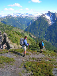
 This hike is a grunt that’ll leave you feeling like an old goat once you reach this 6,600-foot-plus summit in the North Cascades. But you’re well rewarded with some of the finest mountain scenery in all of North America. Mounts Baker and Shuksan, the jagged Pickett Range, and a serrated skyline of British Columbia Peaks are all in the lineup.
Start in thick forest and quickly gain elevation. Just shy of two miles enter the Mount Baker Wilderness. Shortly afterward, pass an unmarked side trail to an old lookout site. Skip it — the good views lie straight ahead and upward. The thick forest soon thins, replaced by a jungle of shrubby mountain ash, maple, alder and willow.
Those scrappy trees soon yield to low-lying blueberry bushes and open meadows granting expanding views. Reach a 5,100-foot knoll with a knockout view of glacier harboring Mount Shuksan cradling glistening Price Lake in a high cirque.
The trail continues along the spine of a ridge, officially terminating at 5,600-feet in expansive meadows. From here you can continue on a rough but well-defined route up flower-studded steep slopes. After a long traverse and insanely steep climb, reach a lofty shoulder and amazing views north to BC’s infinite summits.
Then turn right and follow the ridgeline reaching a 6,650-foot high point after a half mile of some of the most incredible alpine viewing in the North Cascades. Admire your immediate surroundings too, like the small glacier directly below. Goat’s actual high point requires crossing a dangerous snowfield and scrambling exposed rock. Leave it for the peak’s namesake.
Goat Peak, Methow Valley
Roundtrip: 5 miles
Elevation Gain: 1,400 feet
Green Trails Map:
Mazama, WA- No.51
Fees/Restrictions: none —
kid-friendly hike
Compared to Mount Baker’s goat, this goat—standing sentinel over the Methow Valley—is short and sweet. I kid you not! One of two active fire lookouts in the Methow, Goat was chosen for its stand-alone position over the rolling prone-to-lightning strikes terrain. But the views are striking too, especially of the snaking Methow River below.
From Goat Peak’s mile-high trailhead enjoy some fairly easy ambling before the trail kicks into gear. Forest cover thins as elevation is gained. A series of small knolls will have you on a roll as you march toward the summit.
En route to the 7,001-foot summit, traverse pleasant meadows sprinkled with clumps of tenacious trees. Soon the lookout tower guides you in like a beacon. Now enjoy the views: North to the stratosphere-reaching pointy pinnacles of the Pasayten Wilderness; east to the golden slopes of the lofty Tiffany Highlands; and south to stellar Silver Star Mountain shining supremely among its North Cascades neighbors.
Goat Mountain, Mount St. Helens
Roundtrip: 7 miles
Elevation Gain: 2,000 feet
Green Trails Map: Spirit Lake No. 332
Fees/Restrictions: none — kid-friendly and dogs allowed on trail
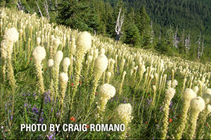
Quiet and lonely, this Goat Mountain is located at the edge of the Mount St. Helens’ 1980 blast zone. While most of this peak’s majestic forest cover was blown down and or incinerated when Mount St. Helens blew its top on that fateful May day, Goat’s open slopes now burst with wildflowers and sweeping views. And hummingbirds! Hundreds of them flit and dart through the sweet scented blossoms lining the way. Wear red and these little birds will keep you alert as they zoom in for a look.
Begin in an old cut and commence on a relentless climb. Utilizing steep switchbacks, gain nearly 1,500 feet within 2.5 miles. Crest Goat’s long ridge and pass by an unmarked side trail leading to a small tarn often harboring wildlife. Now on a much gentler course traverse just beneath Goat’s 5,500-foot summit hanging around the 5,000-foot line for a good mile and a half. Stop whenever you’d like or continue onward dropping to Deadman’s Lake.
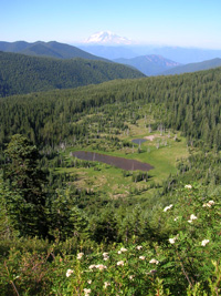
But do enjoy traversing the pumiced slopes admiring silver snags and breathtaking views. Mount Rainier floats on the northern horizon providing a beautiful backdrop to a basin of small lakes frequented by herds of elk. To the east, Mount Adams holds up the sky. And to the south, Mount St. Helens smolders while pointy Mount Hood jabs clouds drifting by.
Getting you on your way
Trailhead Directions
Goat Mountain (Mount Baker Wilderness): From Bellingham, follow SR 542 (Mount Baker Highway) east for 47 miles turning left onto FR 32. Continue for 2.4 miles to trailhead.
Goat Peak (Methow Valley): From Marblemount, follow SR 20 east to the Mazama Turnoff. In a half mile reach Mazama and turn right onto Goat Creek Rd. Follow for 1.9 miles turning left onto to FR 52. After 2.8 miles turn left onto FR 5225. In 5.6 miles turn right onto FR Spur 200 and continue for 3 miles to trailhead.
Goat Mountain (Mount St. Helens): From Randle on US 12, follow SR 131 south for 2 miles to FR 25 continuing for another 6.7 miles. Bear right onto FR 26 following for 12.3 miles; then turn right onto gravel FR 2612 and proceed for .4 mile to trailhead.
Resources
Goat Mountain (Mount Baker Wilderness): Mount Baker Ranger District: Mount Baker Snoqualmie National Forest
(360) 856-5700; http://www.fs.fed.us/r6/mbs/
Goat Peak (Methow Valley): Methow Valley Ranger District: Okanogan National Forest (509) 996-4003; www.fs.fed.us/r6/oka
Goat Mountain (Mount St. Helens): Cowlitz Valley Ranger District (Randle) (360) 497-1100 http://www.fs.fed.us/gpnf
Craig Romano is Trails Editor of Outdoors NW and is the author of eight Northwest hiking guidebooks including his latest Backpacking Washington (The Mountaineers Books), which includes 70 trips throughout the state. Visit him at http://CraigRomano.com.


