NW Trails: The Table is set
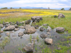
The ‘Table’ is set for some great hiking
Story and Photos by Craig Romano
Okay, it’s time to leave your seat and head for the table. A Table Mountain, that is, and the Northwest is arranged with several.
Evidently, early cartographers and explorers couldn’t come up with a better name for describing several flattop ridges and peaks than with one after a utilitarian piece of furniture. No matter —the uninspiring names don’t diminish from the outstanding features of the following three hikes. These three tables are set with fascinating geology, stunning views, and rewarding hiking.
And there’s no need to ask to be excused from them after you’re done!
NW Trails is sponsored by:
Table Mountain – Mount Baker Wilderness
Roundtrip: 3 miles
Elevation Gain: 600 feet
Green Trails Map: Mount Baker Wilderness Map 13S
Fees/Restrictions: Northwest Forest Pass required; dogs prohibited
Special Note: Road from Mount Baker Ski Area is still snow bound requiring about a 3-mile walk to trailhead. Check with ranger on road status.
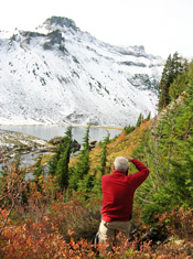
A giant basaltic anvil wedged between the volcanic snow cone of 10,778-foot Mount Baker and the stunning precipitous 9,127-foot Mount Shuksan, Table Mountain at 5,700 feet serves some of the most stunning views in the Northwest. It’s a short and slightly exposed hike up rock steps and along a craggy face to this barren block of a mountain. Snow-covered for most of the year (and sometimes throughout the year) if the trail is cloaked in white, it’s dangerous and should be avoided. Opt instead for nearby and safer Artist Point Trail.
However, if this table has been cleared of snow, set out from a mile-high trailhead up the closest thing to a mesa in the North Cascades. Admire the impressive stone work of the Civilian Conservation Corp trail builders — and clutch your heart gasping at the breathtaking views from every step.
Emerge on the broad open peak and wander past small reflecting pools and clumps of tenacious trees. Look for ptarmigans nestled in the ground-clutching shrubbery. You’ll have a hard time keeping your nose to the ground with so much spectacular scenery surrounding you: Baker, Shuksan, pointy peaks north into British Columbia and east into the heart of the North Cascades — and directly below, the twinkling iceberg harboring Bagley Lake. You won’t be getting up from this table anytime soon.
Table Mountain – Columbia River Gorge
Roundtrip: 9 miles
Elevation Gain: 3,425 feet
Green Trails Map: Columbia River Gorge – West No. 428S
Notes: Hike is extremely difficult and involves scrambling up a talus slope.
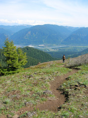
Being seated at this table requires stamina, strength and tenacity. One of the most challenging hikes within the Columbia River Gorge National Scenic Area, Table Mountain is an exhilarating adventure! It’s also an ecological and geological gem; harboring endemic plants and the remnants of a past monstrous landslide that dammed the Columbia River!
Start off easy enough through lush forest to marshy Carpenters Lake. Then follow an old woods road to the Pacific Crest Trail. Enjoy a little easier wandering before reaching the beginning of the Heartbreak Ridge Loop Trail, which may not break your heart but will probably burst your lungs as you gain 1,650 feet within 1.2 miles! And while the way is not exposed, it can be dangerous, especially in bad weather.
The trail climbs at an insanely ridiculous grade reaching a saddle just beneath the impressive face of the mountain. It then heads up a large talus slope before resuming on real tread and reaching a junction.
You’ll want to head back down the trail to the left for a slightly less steep route. But first the summit waits. Turn right and after .3 mile reach Table’s 3,400-foot summit and embrace vertigo-inducing heart-pounding views. Stare down if you dare at the sheer 1,000-foot plus cliffs. Not a place for children, dogs, or the easily unnerved. But what a view — especially of the 11,000-plus foot Mount Hood hovering above the Columbia River.
After view feasting, retrace your way back to the junction and take the Westway Trail for an arduous descent. Reach the Pacific Crest Trail (how are your knees?) and return back to the trailhead. Contemplate soaking at the Bonneville Hot Springs Resort. You deserve it!
Table Rocks – Rogue River Valley, Southern Oregon
LOWER TABLE ROCK
Roundtrip: 5.4 miles
Elevation Gain: 780 feet
UPPER TABLE ROCK
Roundtrip: 2.5 miles
Elevation gain: 720 feet
Fees/Restrictions: Dogs prohibited
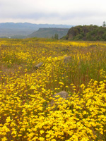
The Table Rocks are a pair of prominent mesas hovering over the Rogue River Valley in southern Oregon, granting exceptional views of both the Cascades and Siskiyou Mountains and offering miles of delightful kid-friendly wandering. Consisting of columnar slabs 800 feet high, the Table Rocks are quite imposing viewed from the valley. But once upon their sprawling flat summits, they’re inviting and soothing — especially when draped with a dazzling floral display. Over 75 species of flowers decorate the Table Rocks in spring and early summer including the dwarf wooly meadow foam which grows nowhere else on the planet.
Two well-built trails will deliver you to these popular table tops. It’s a 1.25-mile hike to the Upper Table Top where you can roam for an additional mile or so upon its summit. The trail to the Lower Table Rock is longer at 2.7 miles and offers more variety including passing through impressive oak savannahs. This trail, too, is adorned with attractive interpretive signs. And the view over the Rogue River and Kelly Slough is one of the best in the valley.
Getting you on your way
Trailhead Directions
Table Mountain (Mount Baker Wilderness): From Bellingham follow SR 542 (Mount Baker Highway) east for 59 miles to road’s end at Artist Point.
Table Mountain (Columbia River Gorge): From Vancouver, Wash., follow SR 14 east for 38 miles turning left onto Hot Springs Road. Continue .8 mile to Bonneville Hot Springs Resort. Park in large gravel parking lot located northwest of resort (respect patrons’ privacy).
Table Rocks (Rogue River Valley):
Upper Table Rock – Take exit 33 from I-5 in Central Point following Biddle Road for 1 mile. Turn left onto Table Rock Road for 5.2 miles – then turn right onto Modoc Road and follow for 1.5 miles to trailhead.
Lower Table Rock – follow above directions except stay left (at Modoc Road junction) continuing on Table Rock Road for 2.5 more miles. Then turn left onto Wheeler Road reaching trailhead in 0.8 mile.
Resources
Table Mountain (Mount Baker Wilderness):
http://www.fs.fed.us/r6/mbs/
Table Mountain (Columbia River Gorge):
http://www.dnr.wa.gov (Search bar)
Table Rocks (Rogue River Valley):
www.blm.gov/or/resources/recreation/tablerock/index.php
Craig Romano is Trails Editor of Outdoors NW and is the author of eight Northwest hiking guidebooks including Day Hiking Columbia River Gorge (The Mountaineers Books), which includes Table Mountain and 99 other hikes. Visit him at http://CraigRomano.com.


