Biking the McKenzie River Trail
One of the best in the nation
By Suzanne Johnson
We hoisted the bikes, one by one, up to Russ, our shuttle driver. He staggered them across the roof racks of the 12-person van, while the rest of our group double-checked their gear: helmets, gloves, hydration packs filled with energy bars, maps, extra windbreakers, spare tubes and patches, CO2 cartridges and first aid kits.
What started off sounding like a day of recreational biking now resembled a covert military operation, and we wondered what exactly we had gotten ourselves into.
The trail’s fame
Riding the McKenzie River Trail through Oregon’s Willamette Valley is one of those epic adventures that should be on every biker’s must-do list. It’s no wonder the trail was voted America’s #1 bike trail in 2008 by Bike Magazine.
The McKenzie River was designated a National Wild and Scenic River in 1988 to protect the exceptional clarity of its water and the high quality of its fish habitat. Flowing out of Clear Lake, about halfway between the towns of Eugene and Bend, the river tumbles and rolls 90 miles south and west through the Cascade Range, finally joining the Willamette River just north of Eugene.
The river was named for Donald MacKenzie, a Scottish-Canadian explorer who led an expedition here in 1812. Unlike us, he didn’t have the chance to follow the river’s bank by mountain bike.
The bike trail is a well-defined single-track that follows along the upper 26 miles of the McKenzie River. Between the old growth forests, the falls and pools of the river, and the exertions of navigating through rolling fields of volcanic rock, it’s an experience that makes an impact. Occasionally that impact is quite literal, especially on the challenging upper portion.
Riding this trail does take some logistical planning. It’s a one-way ride, mostly downhill, so riders are dropped off at the trailhead and picked up at the endpoint. Do-it-yourself shuttling is possible, with two cars and extra time to leave one car at the end of the trail.
We went with a more convenient option, and hired Cog Wild, a mountain biking service out of Bend. The Cog Wild drivers couldn’t ride with us, as guides are not permitted on Wild and Scenic designated rivers, but they are very knowledgeable about the terrain and the trickier parts of the trail. We felt in good hands with Russ, our Cog Wild shuttle driver, as we prepared for the day.
Starting Out
 We pulled into the Fish Lake parking area at the trailhead to unload, go over the map, and establish meeting points. Instead of parking the van at the endpoint, Russ decided he’d wait near the intersection of Highway 126 and Forest Road 2654, where Deer Creek meets the McKenzie.
This point is about two-thirds of the way down the trail, and a convenient spot for riders wanting to finish early, whether due to an injury or a mechanical problem, or pure exhaustion—all three conditions happen frequently on this challenging trail. If we didn’t need him there, he’d continue on to the endpoint.
Upper McKenzie
The first mile or so of rolling, hard-pack single-track served as a good warm-up, almost lulling us into wondering what the fuss was all about. This wasn’t so hard. Once we passed Clear Lake, however, the real challenge of the McKenzie River Trail began.
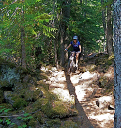
The upper portion of the trail wound along the side of a ridge, hugging up to massive, overhanging conifers and bouncing over ruts and roots in some sections, and twisting through narrow passageways of lava rock in others.We were off our bikes numerous times, picking our way through the more precarious stretches on foot—lava rock is very unforgiving.
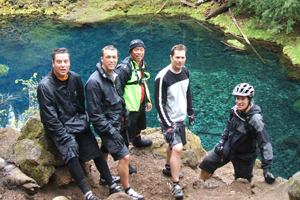
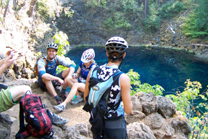
At times it took an effort to peel our eyes from the trail to take in the views, as we passed the tumbling water of Sahalie and Koosah falls. Shortly after these scenic cascades of water, the river ducks underground, re-emerging almost six miles later in the spot that makes all this riding worth the effort: just after a particularly frustrating section of steep, craggy trail, the path pops out onto a ledge overlooking the Blue Pool.
The true name is Tamolich Falls, but Blue Pool is more descriptive and recognizable to any rider who’s been to this magical spot. It’s a calm, clear sapphire pool that fills from the underground river and drains at the far end, transforming the McKenzie back into a raging river.
Lower McKenzie
A few miles beyond Blue Pool, the trail began to mellow. Tight, tricky descents eased into more negotiable single-track, yet often edged along hillsides where the drop-offs were quite steep. The lower portion didn’t require the degree of focus and skill of the upper portion, but we expended a good deal of energy here on sustained, not-so-gentle climbs that rolled through the final miles.
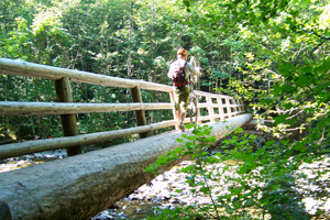
As the elevation dropped, maples and aspens filled in among the firs and cedars, softening the landscape. Massive hand-cut log bridges crossed the smaller rivers that join the lower McKenzie; we had to wheel our bikes across the narrowest of them. These bridges provide good landmarks for bikers to regroup if they’ve been separated along the way, and to break for water and snacks.
Keep the map handy, because the trail crosses or parallels forest roads several times over the final seven miles or so. It would have been easy to take a wrong turn, but luckily we kept our bearings.
Just when it seemed the trail would go on forever, after our legs had turned to rubber and we’d drained our hydration packs, a welcome sight emerged through the trees: the peaked roof of the McKenzie Ranger Station. The amenities here are limited, but there are restroom facilities and drinking water.
The parking lot was filled with sweaty, dirty bikers comparing scrapes and swapping stories of their ride. We were relieved to see Russ and the shuttle van, ready to take us back to our inn for hot showers and a meal.
We’d conquered the McKenzie.
(Directions to Trail Head: The trailhead sits midway between Eugene and Bend on Highway 126, a few miles west of Highway 20. Watch for the Old Santiam Wagon Road sign just before the parking area, or park at the Fish Lake day use area. If your group is self-shuttling, continue on down Highway 126 another 20 miles to the McKenzie Bridge Ranger Station, and leave your return vehicle there.)
If you go
The trail is usually snow-free late spring through late fall. Check with the Ranger Station (541) 822-3381 to verify conditions.
Be realistic about your skill level. Good riders can cover the entire trail in about four hours; if this seems too long, arrange your shuttles for a shorter ride.
Stock a cooler with sandwiches and snacks for the drive home. There are no restaurants or convenience stores along this stretch of highway, and your group will be famished.
Find a map online at www.McKenzieRiverTrail.com, or check local bike shops in Bend or Eugene. AdventureMaps (http://www.adventuremaps.net/central_oregon_trail_map) makes an excellent map, with detailed topography on tear-resistant paper of this area.
Pack a set of dry clothes to leave in the vehicle to change into post-ride, and a plastic bag for the wet, smelly biking clothes and shoes.
Most cell phones have no coverage along the trail, so establishing points to re-group is important for safety. No riders left behind!
Resources
McKenzie Ranger Station: Open Monday–Friday, 8 a.m. – 4:30 p.m., seven days a week from Memorial Day to Labor Day;
(541) 822-3381
Cog Wild: http://www.cogwild.com
(866) 610-4822
Visit McKenzie River:
http://visitmckenzieriver.com/new/
Check here for tourism information on the area.
Lodging: McKenzie River Mountain Resort:
http://www.mckenzierivermountainresort.com/
Lodging can be scarce in this remote area. The McKenzie River Mountain Resort is one of the closest to the Trail. They also offer a shuttle service.
Belknap Hot Springs:
http://www.belknaphotsprings.com/
This funky place has lodge rooms, cabins, tent and RV options, all with access to their hot springs for a post-ride soak.
Suzanne Johnson lives, writes, and plays in the Cascade Mountains of Central Oregon. Find more of her travel writing at OregonAdventurist.com.




Lynn Green, 10 months ago
Are there hiking trails to view the blue pool?
Editor, 10 months ago
Hi Lynn,
While people often mountain bike for this adventure, it does look like you can hike to the Blue Pool: http://www.everytrail.com/guide/mckenzie-river-trail-hike-to-tamolitch-blue-pool
Happy adventuring!