Hiking the Klickitat Trail near the Washington-Oregon border

NW Trails: Hike/bike this 31-mile trail amid spectacular river scenery
Story and Photos by Craig Romano
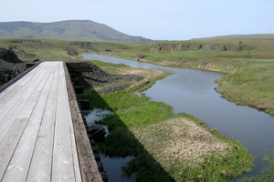
Photo at right: Before entering the Swale Canyon, the trail traverses a high valley.
The Klickitat Trail winds for 31 miles along the Wild and Scenic Klickitat River and spectacular Swale Canyon. Located within the shadows of Mount Adams in the eastern end of the Columbia River Gorge, the Klickitat Trail is one of the prettiest rail trails in Washington. Consider an end-to-end journey on it from the Klickitat Valley to the Columbia River.
NW Trails is sponsored by Green Trails Maps
One of only a few federally protected Wild and Scenic rivers in Washington, the Klickitat is coveted by kayakers and teeming with birds. Look for mergansers riding the currents and kingfishers scrutinizing the currents for bounty.
The trail makes for a wonderful all-day mountain bike trip or ultra-run, or you can hike it in sections thanks to numerous access points. Autumn with its cooler temperatures is a great time to visit.
Wetlands, Wildlife and Trestles
For a one-way adventure, start at the Swale Canyon trailhead (elev. 1,550 feet) for a predominantly downhill journey to the Columbia River trailhead (elev. 150 feet).
Starting from the western edge of the Klickitat Valley (actually a high plateau between the golden Columbia Hills and piney Simcoe Mountains) begin your long slow descent following Swale Creek into Swale Canyon.
Pass wetlands that teem with croaking frogs and singing birds in the spring months. Then cross the first of many attractively restored trestles, compliments of the Klickitat Trail Conservancy (KTC) volunteers.
Good Stewardship Advised
The Klickitat Trail almost didn’t become a reality due to a contingent of mostly abutting property owners who didn’t believe the public had a right to a public right-of-way. But due to the tireless efforts of the KTC and others, the trail prevailed. The northeastern 15 miles of trail are managed cooperatively by the KTC, and Washington State Parks.
It is absolutely imperative that you adhere to all posted regulations — particularly keeping your dog leashed and not leaving the trail right-of-way onto adjacent private property. Be sure to close all gates you pass through, too. While tensions over the trail have simmered, help assuage abutting property owners of their concerns by being a good steward.
Basalt Ledges and Sun-kissed Rocks
Now pass basalt ledges as you wind down into the canyon. The surroundings are both harsh and beautiful. Sage intermixes with willows and dogwoods along the creek. As you progress farther into the canyon, groves of stately oaks and ponderosa pines greet you. Just beyond the fourth trestle at about 5.7 miles is a lovely spot along the creek where smooth sun-kissed rocks invite you to sit, snack and soak.
History and Scenery along the Klickitat River
Beyond, the trail eventually comes to a long and attractive trestle. The way then passes an old pasture and several residences before reaching the Wahkiakus Road Trailhead. The next three miles of trail travels along the Klickitat River.
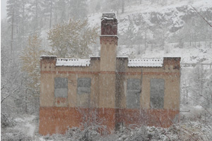
This section makes for nice lonely walking to a mineral spring and the remains of an old dry-ice factory. It is one of my favorite sections of the trail. However, a missing trestle requires that you return to the Wahkiakus Trailhead.
To continue hiking the trail in its entirety, you’ll need to walk or ride your bike west on SR 141 (which runs parallel to the trail here) or catch a shuttle to the small town of Klickitat (located a short distance west of the Wahkiakus Trailhead) where you can resume traveling on the trail. Then hike or ride through the old mill and railroad town of Klickitat passing lots of historic structures including an old inn.
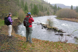
After three miles come to the Pitt Trailhead in the community of Pitt, which was once a gravel pit—having received its name from the railroad company that used the gravel to help build the railway grade. Continue next on what is perhaps the most scenic section of the trail —10-plus miles along the churning glacier-born Klickitat River.
Wild and Scenic
After passing through a gate and skirting a few private properties, enter a wild canyon. The trail undulates through pine and oak groves and along the river’s rocky banks.
Pass a lone homestead, which is connected to the outside world (and road) by a cable crossing the river. Then reenter lonely canyon country. With SR 142 on the opposite side of the river, enjoy miles of roadless, houseless, semi-wild walking.
Cross tribal land at “the Narrows,” a deep basalt chasm. Look here for planking suspended above the roiling river. Native Americans dip-net fish from them; one of only two areas within the Columbia River drainage where this practice is still engaged.
Cross Fisher Hill Road (alternative trailhead) and continue south crossing the Klickitat River on a restored high trestle.
The trail soon afterward enters the Columbia Gorge Natural Scenic Area and becomes paved allowing wheelchair users a chance to experience this wonderful trail. The way then slowly descends to its southern terminus in the little community of Lyle located at the confluence of the Klickitat and Columbia Rivers.
Wintering Bald Eagles
During the winter months this area hosts large concentrations of wintering bald eagles. The Balfour-Klickitat Trail, a wonderful paved nature path along the Klickitat River, lies just a short distance to the west of you. If you still have energy, check out the Balfour-Klickitat Trail, one of the best places in the Columbia River Gorge for observing wintering eagles.
Getting you on your way
Klickitat Trip Details
Distance: 31 miles end to end
Trailhead Directions:
Northern Terminus: From Portland, drive I-84 east to Exit 64 in Hood River taking the toll bridge into Washington. Turn right on SR 14 and drive 11.1 miles to Centerville Road in Lyle. Follow this road for 14.5 miles turning left onto Harms Road. Reach trailhead in half a mile
Southern Terminus: From Portland drive I-84 east to Exit 64 in Hood River taking the toll bridge into Washington. Turn right on SR 14 and drive 10.7 miles to Lyle and trailhead.
Green Trails Map: Columbia Gorge East No. 432S
Notes: Dogs must be leashed; Swale Canyon portion of trail closed from approximately July 1 – Oct. 1 because of fire danger.
Contacts: Klickitat Trail Conservancy, www.klickitat-trail.org
Craig Romano is Trails Editor of OutdoorsNW and is the author and co-author of 12 Northwest hiking guidebooks including Day Columbia River Gorge (The Mountaineers Books), which includes 100 hikes from Portland to The Dalles. Visit him at www.CraigRomano.com


