NW Trails: Artist Point
An invigorating snowshoe trip to an inspiring point
Story and Photos by Craig Romano
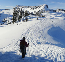
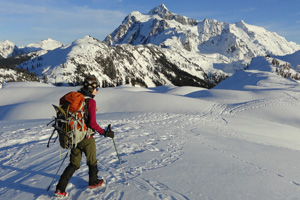
Photo at right:A snowshoer hikes across Artist Point toward Mt. Shuksan.
Stand upon Artist Point on a crisp, cool winter bluebird day, and you’ll swear that somewhere along the way you were magically etched into the largest and most gorgeous canvas ever painted.
Glorious Wilderness Setting
From this lofty snowy perch punctuated with contorted hemlocks, you’re framed by two of the most massive glacier-covered and iconic mountains in the state. It is definitely one of the most stunning settings anywhere. And, for all of Artist Point’s glorious wilderness setting, it doesn’t require a lot of energy or technical skill to reach it.
Thanks to the Mt. Baker Highway, a spectacularly scenic national byway that’s plowed all winter to the Mt. Baker Ski Area at Heather Meadows, Artist Point can easily be reached.
With a starting elevation of 4,200 feet, you immediately begin in a high open sub-alpine forest with breathtaking views of nearby frosty mountains.
The route to Artist Point follows a scenic Forest Service road built by the Civilian Conservation Corp in the 1930s. During snowy months, the roadway is closed to vehicle traffic.
The hike is usually safe from avalanches, but it should be avoided during periods of high avalanche warnings. Be sure to always check with the Northwest Avalanche Center before beginning.
Starting from a large parking area, begin your trek south staying outside of the Mt. Baker Ski Area boundaries. You’ll skirt Heather Meadows and stay above the Bagley Lakes, enjoying exceptional views of the frozen slopes of Table Mountain and Mt. Herman. Avalanches are frequent on those slopes, and all but the most expert of backcountry skiers should stay far away from those peaks and the bowls between them.
Climb above the eloquently rustic Heather Meadows Visitors Center, perched on a bluff above the lakes. Constructed as a ski warming hut by the CCC in 1940, the Center now is used during the summer for historical interpretation and outdoor recreation information.
In winter, the Center serves as yet another scenic photo prop in this inspiring landscape. You won’t be able to physically warm up in it, but seeing this lovely stone structure against a snowy backdrop should warm your heart.
After a fairly steep beginning, the way moderates as you travel away from the ski area. Snowshoe through Austin Pass and groves of stately ancient conifers, then traverse a steep side slope before entering a fairly large and open area.
Bend right to skirt beneath Kulshan Ridge (which Artist Point sits upon) eventually making it to the broad open area known as Artist Point, which also serves as a parking lot when the road is open. You may spot the top of an outhouse peeking through drifted snow—or you may not, as the snowfall up here is epic; some of the heaviest amounts ever recorded in North America have fallen in this region.
The views here from Artist Point are certainly inspiring, but they are much better the farther you go along Kulshan Ridge.
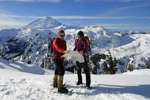
Steering clear from cornices and over-hanging snow drifts, walk east along the rolling frozen ridgeline. Pause to admire clusters of windblown hemlocks adorned in winter regalia. And, stop frequently to capture on pixels, your mind’s eye, or on canvas, one of the most gorgeous views in the Northwest.
You are standing between two of the North Cascades’ most admired peaks, 9,131-foot Mt. Shuksan—one of the most photographed mountains in the country, and 10,778-foot Mt. Baker—Washington’s third highest and snowiest summit.
And, the scenery south across the Swift Creek and Baker River valleys and north to the craggy cloud-catching peaks that line the Washington and British Columbia boundary, is no less jaw-dropping.
Snowshoe as far east as 5,200-foot Huntoon Point, a mere two miles from your start, while feeling like you are hundreds of miles away from civilization. Spread out the space blanket, pull out the thermos and pour yourself a cup of hot tea or soup. Guard your crackers from lunch-marauding gray jays and sit for as long as you can in this winter environment. Savor the serenity, too, of this wild land blanketed in a snowy shroud.
When you must, slowly return the way you came—admiring the long shadows on the slopes cast by stately trees and languid snowshoers. Excite over the prospects of returning in the spring—or, better yet, make a trip here during a full moon. You may discover that the only thing grander than Mts. Baker and Shuksan covered in snow—are their icy silhouettes against a starry night sky.
Getting you on your way
Trip Details
Distance: 4 miles round-trip with 1,000 feet of vertical elevation
Trailhead Directions: From Bellingham, follow SR 542 (Mt. Baker Highway) east for 56 miles to the Mt. Baker Ski Area Lodge (upper lot) at Heather Meadows turning right into a large parking area.
Green Trails Maps: Mt. Baker Wilderness Climbing 13S
Notes: Do not snowshoe on groomed ski trail. Check avalanche conditions from Northwest Avalanche Center (www.nwac.us) before departing and know safe backcountry snow travel techniques.
Contacts: Mt. Baker-Snoqualmie National Forest; www.fs.usda.gov/mbs
Craig Romano is Trails Editor of OutdoorsNW and is the author of nine Northwest hiking guidebooks including Day Hiking North Cascades (The Mountaineers Books), which includes more hikes near the Mt. Baker Highway.

