NW Trails: Urban Hiking

Rose City blooms with excellent hiking destinations
Story and Photos by Craig Romano
You’ll have a hard time finding a major metropolitan area in America more integrated with nature than Portland, fondly dubbed “the Rose City.”
A leader in land planning, green belting and trail development, Portland is the type of urban area that a rural dweller can love.
And there is much to love about the Rose City if you’re a hiker. The city boasts over 10,000 acres of parkland including one of the largest urban parks in the country: 5,000-acre Forest Park — the city’s green backdrop.
You can hike through deep forests, along undeveloped shorelines teeming with wildlife and across crest peaks providing outstanding views — all without even leaving the city.
Interested? I’ve come up with three choice hikes to get you exploring the wilder side of Oregon’s largest city.
NW Trails is sponsored by:
Balch Creek Canyon
Roundtrip: 2.4 miles
Elevation Gain: 300 feet
Green Trails Map: Forest Park No 426S
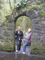
Balch Creek slices through Macleay Park (a gift to the city in 1897, since absorbed into Forest Park) via a gorgeous ravine. Perhaps the most scenic trail within Forest Park, Balch Creek will delight hikers of all ages with its waterfalls, old-growth groves, and the ruins of an eloquent old stone building that once offered relief to weary walkers.
Begin by hiking under a high old bridge before reaching Balch Creek. Cross the creek and continue on good trail through a magnificent canyon. Pass charming cascades and rapids before crossing the creek once more — this time above a pretty little waterfall. Continue upstream through groves of Portland’s biggest and oldest trees.
At .9 mile, reach the 30-mile long Wildwood Trail at the remains of the old stone house. This intriguing building may have you pondering its origin. Built by the Works Project Administration (WPA) in 1936, it served as a public restroom until 1962!
Continue now on the Wildwood Trail upstream for .3 mile, coming to another bridge over Balch Creek. From here, the trail climbs out of the canyon, making this a logical turnaround spot. Take your time on the return.
Tryon Creek State Natural Area
Roundtrip: 2.1 miles
Elevation Gain: 330 feet
Map: State Park map available at visitor center and online.
While Forest Park is often touted as Portland’s premier nature park, Tryon Creek is my favorite.
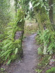
Less crowded, Tryon Creek is peaceful, varied, and graced with a family-friendly trail system allowing for multitudes of loop options. And it’s all centered on a pretty little creek that meanders through an emerald ravine within a 670-acre state park right on the city’s edge.
There are about eight miles of hiking trails, 3.5 miles of equestrian trails and a three-mile paved bike path in the park. Trails and junctions are well-marked and the park map (free and available at the visitor’s center) is accurate and indispensible.
For a nice introductory loop, start by following the Maple Ridge Trail west from the Nature Center to the Middle Creek Trail dropping into the lush emerald ravine containing Tryon Creek.
At a major trail junction, cross the salmon-harboring waterway on High Bridge, one of several delightful bridges spanning Tryon Creek. Then turn left and continue on the Middle Creek Trail following the creek downstream.
At about .2 mile from High Bridge, veer right onto the Cedar Trail making a big horseshoe route around a quiet ravine, housing — yep — cedars! Bear left onto the Red Fox Trail, taking this path back over Tryon Creek and climbing steeply out of the ravine to the Old Main Trail. Then follow this path back to the visitor’s center.
Warrior Rock Lighthouse – Sauvie Island
Roundtrip: 6.5 miles
Elevation Gain: None
Map: USGS St. Helens
There’s much to love about Sauvie Island, Oregon’s largest island. Located a mere 10 miles from downtown Portland, this 24,000-plus acre island with a people population of just over 1,000, is nearly all wildlife preserve and farmland. And it’s rife with history, too.
Lt. William Broughton, sailing for Captain George Vancouver, visited in 1792 where he was met at the rocky tip of the island by 150 Chinook Indians dressed in war attire (hence Warrior Rock). Lewis and Clark came through in 1805 and 1806. And in 1836, French-Canadian Laurent Sauvé began managing dairy farms here for the Hudson’s Bay Company at nearby Fort Vancouver. The island bears his name.
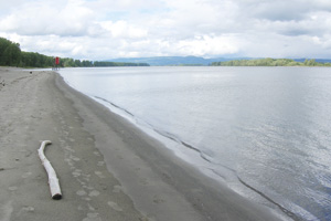
Start by walking a quarter mile on a fine sandy beach. Then head up on the riverbank picking up a closed-to-vehicles dirt road. Soon, bear right onto a more lightly traveled road and follow it under a canopy of giant cottonwoods. Soothing bird song fills the air, occasionally interrupted by harsher sounds of large vessels plying the river. Several trails diverge left and right to beaches and sloughs.
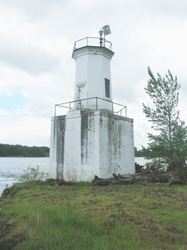
After coming to a small meadow, the way bends rights to end at a 1930-built lighthouse at Warrior Rock. Nearby is a delightful beach. Feel free to snoop around the tip of the island for a good view of the city of St. Helens across the Multnomah Channel.
Getting you on your way
Notes: Dogs permitted on all three hikes but must be leashed; Sauvie Island Wildlife Area Parking permit required ($7/day/$22 annual — available at Cracker Barrel Grocery on island) for Warrior Rock.
Lodging: Visit www.travelportland.com
Contacts
Balch Creek Canyon, Forest Park: www.portlandonline.com/parks
Tryon Creek State Park: www.oregonstateparks.org
Warrior Rock, Sauvie Island Wildlife Area: www.dfw.state.or.us
Trailhead Directions
Balch Creek Canyon: From downtown Portland, follow NW Vaughn Street west turning left onto NW 26th Avenue. After one block, turn right onto NW Upshur Street and continue .4 mile to trailhead at road’s end.
Tryon Creek State Park: From Portland, follow I-5 south to Exit 297. Turn right onto Terwilliger Boulevard and continue for 2.3 miles to park entrance and trailhead at nature center.
Warrior Rock: From downtown Portland, follow US 30 (NW St. Helens Road) west for 11 miles, turning right onto the Sauvie Island Bridge. Follow Sauvie Island Road, turning right in 2.1 miles onto Reeder Road. Continue for 12.7 miles to trailhead at road’s end.
Craig Romano is Trails Editor of Outdoors NW and author of eight Northwest hiking guidebooks with Mountaineers Books including the upcoming Day Hiking Columbia River Gorge (Spring 2011) which contains a chapter on Portland hikes. Visit him at http://CraigRomano.com


