NW Trails: Hiking Horseshoe Basins

Dead Ringers for Great Backpacking Trips North Cascades, Methow Valley, Chelan
Story and Photos by Craig Romano
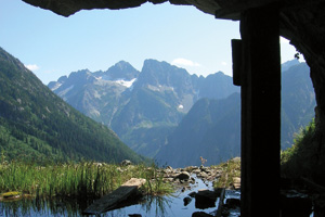
Photo at right: Basin Creek Valley and Trapper Mountain from the shaft of Black Warrior Mine in the North Cascades
NW Trails is Sponsored by:
Horseshoes are said to bring good luck. Backpackers always need a little good luck—especially when it comes to finding good trails, campsites, views, and weather. Packing a horseshoe in your pack seems impractical, although not unheard of. (I saw this once while hiking the Appalachian Trail.)
Keep the horseshoes on the horses and consider a backpacking trip to a horseshoe basin, instead. You’ll find a trio of them in Washington’s North Cascades. They’re all excellent destinations with guaranteed good trails, campsites and views. As for good weather, well, you may need a horseshoe for that. Have fun!
Horseshoe Basin — North Cascades National Park
Roundtrip: 17 miles
Elevation Gain: 4,550 feet
Fees/Restrictions: dogs and campfires prohibited; National Park backcountry permit required (free) for camping.
Green Trails Map: Cascade Pass, No. 80
Many a backpacker has ventured up Cascade Pass and then continued up Sahale Arm to frolic with gregarious marmots and take in breathtaking views of a surrounding fortress of snow and rock. However, it can get downright crowded on Sahale Arm. A far less crowded option is to head to the Stehekin Valley and Horseshoe Basin.
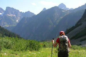
From the busy trailhead, steadily climb up a steep hillside. After 3.7 miles of traversing old-growth, meadows, talus and perhaps a lingering snowfield or two, you will reach the 5,400-foot Cascade Pass. Marvel at the views, especially the formidable icy wall to the south. Then ditch the crowds by dropping into the Pelton Creek Basin, a hanging valley of cascading waters tumbling down spiraling icy walls. Find Pelton Basin Camp here—it’s a great place to set up for the evening.
The trail continues descending into the Stehekin Valley crossing Doubtful Creek, which may be challenging in high water. Seven miles from the trailhead, you’ll reach a junction. If you’re spending the night at Basin Creek Camp, it’s another half mile on the right. For Horseshoe Basin, continue left 1.5 miles into the large amphitheater-like basin. Admire the surrounding sheer walls capped with hanging glaciers, which feed no less than a half dozen silvery strands of cascading creeks.
Old mining relics lie littered among blossoms and boulders. They’re from the Black Warrior Mine, which operated until the late 1950s. Snoop around, but don’t venture beyond the shaft’s entrance. The view from the mine over the Basin Creek Valley to Trapper Mountain is a North Cascades classic.
Horseshoe Basin — Pasayten Wilderness
Roundtrip: 14 miles
Elevation Gain: 1,600 feet
Fees/Restrictions: Wilderness regulations apply; self issued permits (free) at trailhead
Green Trails Map: Horseshoe Basin, No. 21
Situated in the Pasayten Wilderness on the eastern edge of the North Cascades, this horseshoe basin gets lots of sunshine, allowing for early and late-season high country probing. Make the easy trek to this 7,000-foot basin teeming with wildlife. Set up camp, and spend a week scrambling up a half dozen surrounding gentle lofty peaks.
Starting from a trailhead at over 6,100-feet elevation, follow the Boundary Trail along an old mining roadbed. Much of the way is through a forest of charred matchsticks compliments of 2006’s Tripod Fire, a conflagration that scorched over 175,000 acres. Greenery is slowly returning, but this hike can be hot. Pack ample water and sunscreen.
Eventually you’ll reach a verdant meadow and a couple of trail junctions at 7,200-foot Sunny Pass. Continue right to emerald Horseshoe Basin and a three-way junction at Horseshoe Creek. It’s time to decide where to camp. You’ll find good camps on both sides of the creek. Alternatively, you can head right for an easy .8 mile to little Smith Lake tucked beneath Horseshoe Mountain’s larch-covered north slopes.
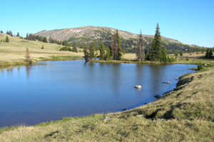
Your best choice is to head left for .8 miles on the Boundary Trail to little Loudon Lake, which is perched on a rolling lawn. Set up camp and contemplate exploring options. Scramble up the tundra slopes of 8,100-plus foot Armstrong Mountain, which straddles the international boundary. Check out the two boundary monuments and gape at views north to B.C.’s Snowy Mountain and Cathedral Park Peaks. Cast your views stateside too, to pointy 8,601-foot Cathedral Peak, broad 8,685-foot Remmel Mountain, and 8,334-foot Windy Peak hovering above Horseshoe Basin.
Horseshoe Basin — Lake Chelan-Sawtooth Range
Roundtrip: 20.4 miles
Elevation Gain: 5,900 feet
Fees/Restrictions: NW Forest Pass required; wilderness regulations apply
Green Trails Maps: Buttermilk Butte, Wash., No. 83
This horseshoe basin lays smack dab in the middle of an exhilarating loop in the jagged Sawtooth Range. Hike across alpine tundra and windswept ridges to a handful of sparkling alpine lakes. This hike, with its abundant larches, is an excellent choice in autumn. There’s lots of elevation to be gained on this loop, but it’s worth the toil.
Start on the Eagle Creek Trail, which will soon enter the Lake Chelan-Sawtooth Wilderness, a 150,000-plus acre wild wedge between the Methow River and Lake Chelan. At your first junction, continue straight up the Oval Creek Trail; you’ll be returning to the right. The trail steadily marches up the valley, reaching a small open basin with good creek side campsites at 6.0 miles.
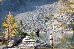
Soon, the route really begins to climb, coming to a spur trail leading .25 mile to gorgeous West Opal Lake. Set beneath talus slopes and granite ledges, it’s a great spot to spend the night. The main trail continues steeply climbing reaching another trail junction. The trail left drops 900 feet in 1.2 miles reaching Middle Oval Lake in a big basin. East Oval Lake lies another .3 mile away. Both lakes offer good camping options.
The loop continues right over rocky windswept barren 7,725-foot Oval Pass. Pause for breathtaking views across the serrated Sawtooth Ridge and down below to the golden grassy lawns of Horseshoe Basin. Consider following a faint track south for .5 mile to 8,104-foot Gray Peak’s open summit for stunning views down to Middle and East Oval Lakes.
From Oval Pass the trail drops steeply to tiny Tuckaway Lake tucked away in Horseshoe Basin, which has good campsites. It’s also good bear habitat, so store food properly. Beyond Tuckaway Lake, the trail drops through flower fields reaching a good forested creekside camp at a junction. Head right along the Chelan Summit Trail across slopes of swaying grasses and flowery knolls granting views to Lake Chelan 6,000 feet below. You’ll reach a lovely basin housing the headwaters of Fish Creek, good camps and a junction with the Eagle Creek Trail.
Follow this trail steeply out of the basin to 7,250-foot Eagle Pass. Then descend, rounding a basin with excellent views of 8,795-foot Oval Peak before entering cool forest. The trail undulates between meadow and forest following Eagle Creek back to the Oval Creek Trail and the trailhead.
Trailhead Directions
Horseshoe Basin – North Cascades National Park: From Marblemount on SR 20, head east on the Cascade River Road for 23 miles to trailhead.
Horseshoe Basin – Pasayten: From Tonasket, follow the Loomis Highway west for 17 miles to Loomis. Bear right onto Loomis-Oroville Road; and after 2 miles turn left onto FR 39. Follow for 13.5 miles turning right onto FR 500 (signed Irongate Trailhead). Continue for 5.7 rough miles (high clearance necessary) to trailhead.
Horseshoe Basin – Lake Chelan-Sawtooth Wilderness: From Twisp, follow Twisp River Road (FR 44) west for 14.3 miles turning left onto FR 4430. Upon crossing Twisp River in .25 mile reach a junction. Turn left onto FR 4420 proceeding for .8 mile. Then turn right onto FR 4420-80 continuing for 1.4 miles trailhead.
Resources
Horseshoe Basin (NCNP): North Cascades National Park (360) 854-7245; www.nps.gov/noca
Horseshoe Basin (Pasayten): Tonasket Ranger District, Okanogan-Wenatchee National Forest, (509) 486-2186; www.fs.fed.us/r6/oka
Horseshoe Basin (Lake Chelan-Sawtooth Wilderness): Methow Valley Ranger District: Okanogan-Wenatchee National Forest (509) 996-4003; www.fs.fed.us/r6/oka
Craig Romano is Trails Editor of Outdoors NW and the author of eight Northwest hiking guidebooks including Backpacking Washington (The Mountaineers Books), where you’ll find more information on these and other excellent hikes. Visit him at CraigRomano.com


