NW Trails: Island Hiking

Exploring Puget Sound’s temperate islands
Story and Photos by Craig Romano
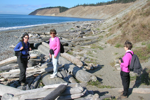
Photo at right: Hikers at Ebey’s Landing on Whidbey Island.
While our mountains may currently be a winter wonderland, that’s no reason to hang up your hiking boots. After all, the weather in the Northwest lowlands is temperate, and there’s no place better for mild winter weather than on our islands.
Not only will you find some great trails and parks among Puget Sound’s many islands, but you’ll also find easy access. Most islands are just a quick drive and/or ferry ride away—and don’t worry about bringing along the tire chains!
NW Trails is sponsored by:
Gazzum Lake and Close Beach
Bainbridge Island (on Kitsap Peninsula)
Roundtrip: 3.4 miles
Elevation Gain: 350 feet
Fees/Restrictions: dogs must be leashed
Kid-friendly
The second largest undeveloped tract on Bainbridge Island, the Gazzam Lake Preserve protects 444 acres of quiet lakeshore, mature forest and a gorgeous stretch of madrona-lined beach along Port Orchard Bay. There are three trailheads and over four miles of hiking in this wildlife preserve. The hike described here offers a good sampling of this island gem.
From the south trailhead, follow an old dirt road past a couple of water towers to a bona fide trail. Soon afterward, come to a junction. Either way will get you to the lake—the path to the right is longer by .2 mile. In .6 mile (or .8 if you took the right fork) the trails meet back up.
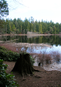
Continue left through an attractive forest of cedar and maple to the 13-acre undeveloped Gazzam Lake. Spur paths lead down to the shoreline. The nicest trail leads to a small open area complete with a bench for watching the lake’s avian residents including buffleheads, cormorants and eagles.
The main trail continues past the lake to reach a junction. The Marshall Road Trailhead is a quarter mile away—an alternative trailhead that offers the shortest route to Gazzam Lake. Close Beach, the best part of this hike, is to the left. Take the left fork, crest a small hill and then steeply descend beneath a canopy of big firs. After .6 mile, reach secluded little Close Beach on Port Orchard Narrows. Plop down on a log and enjoy the sweet smell of salt air along with sublime views of the Kitsap Peninsula and Olympic Mountains.
Cranberry Lake
Camano Island
Roundtrip: 1.5 miles
Elevation Gain: 125 feet
Fees/Restrictions: Discover Pass required; dogs must be leashed
Kid-friendly
Washington’s newest state park, 433-acre Cama Beach, is packed with surprises. Most visitors to this sprawling park on Saratoga Pass while away their time at its charmingly restored 1930s beachside cabins, but for hikers, the park offers several miles of quiet and family-friendly trails.
The short trail to Cranberry Lake is a great choice for sampling the uplands of Camano Island.
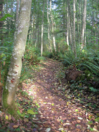
From the shelter at the south end of the parking lot find the trail heading left away from the beach. This is the original access road to the old resort. Now a peaceful path, it meanders beneath a canopy of large firs and maples. Much of the park consists of mature forest like this, which provides excellent habitat to a myriad of wild critters.
After a quarter mile you’ll reach a trail junction and road crossing. The trail right is part of the Cross Island Trail, a work-in-progress. It leads one mile to Camano Island State Park, where several more miles of excellent trails can be accessed. For Cranberry Lake, continue straight, carefully crossing the road.
Soon come to another junction. The trail left is a continuation of the Cross Island Trail. It heads 1.25 miles through quiet woodlands, climbing several hundred feet to Ivy Lane. Consider it for a nice extension to this hike after returning from the lake. But first, to the lake!
Continue straight on a good trail that winds through alders and snowberry bushes as it gently climbs a small ridge. At .75 mile, you’ll reach Cranberry Lake, a shallow body of water that, in springtime, bursts with birds enticed by a shoreline of cattails and spirea.
Ebey’s Landing
Whidbey Island
Roundtrip Loop: 5.6 miles
Elevation Gain: 260 feet
Fees/Restrictions: dogs must be leashed.
Kid-friendly
This is one of my favorite hikes in the entire state. At Ebey’s Landing you’ll stroll across emerald fields, climb towering coastal bluffs, and wander along a beautiful beach against a backdrop of the snowcapped Olympic Mountains.
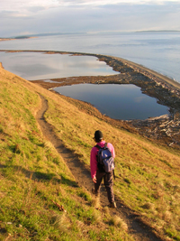
Start from the Prairie Overlook and after a half mile pass a restored 1850s homestead now serving as the historic reserve’s visitor center. Then continue across emerald lawns toward Admiralty Inlet, reaching a junction after another half mile. This hike is a “lollipop loop.” You’ll be returning left. So head right, climbing golden coastal bluffs that are among the highest in the state. Stare straight down at Perego’s Lake, a lagoon formed by a narrow spit littered with giant drift logs. Scope it for shorebirds.
After walking along the bluffs for a mile, come to a junction with a short spur trail heading to an excellent viewpoint. Then steeply descend to a wide beach of hard-packed sand and polished stones. Turn left here and walk south along the beach, rounding the spit and reaching the Ebey’s Landing Wayside after a little more than four miles.
Pick up the trail once again, climbing some stairs back up the coastal bluffs. After about a half mile, come to a familiar junction and return to your vehicle. Extend your hike if you’d like by walking north or south along the beach.
Trailhead Directions
Gazzum Lake: Take Bainbridge Island ferry to Winslow Way and drive through the business district. Turn right onto Grow Ave. In .3 mile, turn left onto Wyatt Way. In .6 mile, turn left onto Eagle Harbor Drive, then after .3 mile bear right onto Bucklin Hill Road. After .3 mile, bear right and in .2 mile bear left onto Lynwood Center Road. After one mile, turn right onto Baker Hill Road. In .8 mile, turn right onto gravel Deerpath Lane and proceed for .2 mile to trailhead.
Cranberry Lake: From Exit 212 on I-5, travel west on SR 532, passing through Stanwood and coming to a junction at 10 miles. Bear left onto N.E. Camano Drive and proceed for 2.5 miles. Turn right onto S. Camano Hill Road, continuing for 3.4 miles to a junction with S.W. Camano Drive. Turn left, reaching Cama Beach State Park entrance in 2.8 miles. Turn right, reaching the trailhead in .3 mile.
Ebey’s Landing: Take the ferry from Mukilteo to Clinton on Whidbey Island and travel north on SR 525 for 19 miles. Bear right onto SR 20, continuing 5.5 miles to the Coupeville traffic light. Continue north on SR 20 for .8 mile. Turn left onto Sherman Road. Proceed for .3 mile, turning right onto Cook Road. Reach Prairie Overlook trailhead in .3 mile.
Resources
Gazzum Lake (Bainbridge Island Metro Parks): www.biparks.org
Cranberry Lake (Cama Beach State Park): http://www.parks.wa.gov
Ebeys Landing National Historical Reserve: http://www.nps.gov/ebla


