NW Trails: Bike and Hike Williams Lake and Dutch Miller Gap
Bike-hike to an old mining district in the heart of the Alpine Lakes Wilderness
Story and Photos by Craig Romano
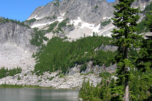
Photo at right: Williams Lake with La Bohn Gap in the distance.
When the upper reaches of the Middle Fork Snoqualmie Road were decommissioned to vehicles a few years back, more than a few hikers bemoaned the action.
A big, sparkling alpine lake near a dramatic pass on the Cascade Crest was no longer accessible as a day hike.
NW Trails is sponsored by:
Of course, more than a few hikers welcomed the road closure as well, realizing that Williams Lake and Dutch Miller Gap just got wilder.
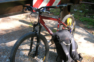
Hardy hikers can still reach these rugged and beautiful destinations in a day, if they look to their mountain bikes. That’s what I did on my most recent trip to Williams Lake. It’s still a grunt and quite challenging, but doable in a day. If you’re looking to backpack in and spend a night or two, still consider using your bike. You’ll be more than elated on the trip back when you can let gravity do some of the work.
Relics and remnants of the past
Williams Lake is cradled in a rugged cirque within the sprawling Alpine Lakes Wilderness. Bicycles are not allowed in wilderness areas, but are allowed on the decommissioned upper Middle Fork Road and the parallel Middle Fork Trail (on odd-numbered days). Once the domain of miners, prospectors and explorers, there are lots of relics and remnants of the past to be discovered along the way. You may even come upon Andrew Jackson “Dutch” Miller’s old mine.
From the trailhead you have two options for the biking section of this trip. Either take the Middle Fork Snoqualmie Trail, which snakes along the river through nice groves of old timber for 8.7 miles, or follow the old roadway for 7.7 miles to the former trailhead and start of the hiking section of this trip.
Advantages to the Middle Fork Trail include a prettier approach and nice options for camping along the river. The advantage to using the road is a more straightforward route. It’s quicker and easier (but rockier in spots) too — and you get to pass Dingford Creek Falls.
Both approaches allow for the possibility (preferably on the return) of a visit to the Goldmyer Hot Springs. Privately owned but opened to the public (for a fee), advance reservations are required for soaking and camping.
Beyond the Hot Springs both the road and trail steeply climb to meet up just shy of the old car-accessible horse camp at the original trailhead. It’s now a pretty quiet spot with riverside campsites. Find a good spot here to ditch your bike and start hiking the Dutch Miller Gap Trail.
Immediately come to a bridged crossing of Hardscrabble Creek. Tumbling down from lakes of the same name beneath Big Snow Mountain, be thankful for the bridge or it would be a hardscrabble crossing. The trail undulates between stately groves of old-growth forest and open brushy areas. March up a wide valley surrounded by lofty granite peaks reminiscent of California’s Yosemite Valley.
Enter the Alpine Lake Wilderness and a nice riverside camp before again crossing a large brush-choked opening. With the trail now deeper in the backcountry, it receives less maintenance. After a slight drop along a talus slope, cross one more unpleasant brushy section and pick up good tread in nice cool old-growth forest. Come to Crawford Creek with more good camping options. The way then steepens, passing a thundering waterfall on its way to a hanging valley. Forest yields to marshes and with plenty of mosquitoes in early summer as the trail angles beneath shiny cliffs and big talus slopes.
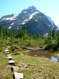
Pass a beautiful tiered-slab waterfall before entering a broad meadow dotted with pools. Reach Pedro Camp, a good but buggy camping area at a flat along the creek. It’s close to a big bridge spanning a refreshing tributary creek.
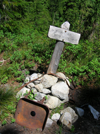
The trail continues, weaving through heather and mountain hemlock groves reaching a junction one mile farther. Williams Lake is to the left at .7 mile. Cross a creek, then briskly climb crossing snowmelt streams and heather meadows. Crest a small rise and then drop to gorgeous Williams Lake (elev. 4,600 feet) tucked in a dramatic bowl beneath imposing 7,197-foot Bears Breast Mountain.
Excellent camps can be found on the bluff just beyond the lake’s outlet, complete with dramatic views south to the icy imposing wall formed by 7,225-foot Little Big Chief, 7,120-foot Middle Chief, and 7,464-foot Summit Chief Mountains.
Sure-footed hikers can follow sketchy tread beyond Williams Lake to cabin ruins, old mines and the Chain Lakes, a group of tarns tucked in a cirque beneath 5,850-foot La Bohn Gap. All hikers can hike the one-mile trail to 5,000-foot Dutch Miller Gap taking in a spectacular view of Waptus Lake and gorgeous Ivanhoe Lake just below —offering yet further possibilities for adventuring!
Getting you on your way
Trip Details
Distance: 30 miles roundtrip
(7.7 miles bike/ 7.3 miles hike)
Elevation Gain: 3,600 feet
Trailhead Directions: From Seattle take I-90 east to exit 34 turning left onto SE Edgewick Road (468th Ave SE). Proceed for .6 mile turning right onto the Middle Fork Road (FR 56). At 2.5 miles, pavement ends. Continue for 9.6 agonizingly slow and bumpy miles to a junction (just after Middle Fork Campground and Taylor River Bridge). Turn right continuing on FR 56 for 5.7 miles on an extremely rough road now passable to high-clearance vehicles only to a gate and trailhead (elev. 1,300 feet).
If road from Taylor River is impassable, start hike from Middle Fork Trailhead near Middle Fork Campground adding 12 miles roundtrip.
Permits Required: Northwest Forest Pass required
Green Trails Maps: Skykomish No. 175; Stevens Pass No 176; Snoqualmie Pass No. 207
Contacts: Mount Baker-Snoqualmie National Forest: www.fs.usda.gov/mbs; Goldmyer Hot Springs: www.goldmyer.org
Craig Romano is Trails Editor of Outdoors NW and the author of nine Northwest hiking guidebooks including Backpacking Washington (The Mountaineers Books), which includes more detailed trail information on this route. Visit him at CraigRomano.com.




Bradley, 1 year ago
Is it possible to make it to the Tank Lakes in a day via this method? Thanks for your write-up!
Editor, 1 year ago
Hi Bradley. Thanks for your question. You might want to check out entries on the WTA site for recent trip reports: http://www.wta.org/go-hiking/hikes/tank-lakes