NW Trails: Cape Horn Trail on the Columbia River Gorge

Cape Horn — New trail in the Columbia River Gorge is already a classic
Story and Photos by Craig Romano
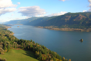
Photo at right: Gorgeous Columbia River Gorge views from the Cape Horn Trail.
There are scores of magnificent hiking trails within the Columbia River Gorge National Scenic Area. Yet, none of them captures the full essence of the Gorge like the Cape Horn Trail.
NW Trails is sponsored by:
On this 7.5-mile loop you’ll experience many of the facets that make the Gorge such a fascinating and magical place. Clamber over oak-cloaked basalt bluffs that precipitously drop to river’s edge. Duck beneath a waterfall tumbling down a stark cliff face. Saunter through maple groves carpeted in spring with resplendent wildflowers. Stroll across hilltop meadows where perpetual breezes sway tall grasses and whistle through contorted firs. And stand upon lofty knolls mouth agape, eyes wide open, beholding some of the most stunning scenery in the country.
One of the Gorge’s newest trails, the Cape Horn Trail, is destined to be a classic! From the trailhead (see Getting You on Your Way sidebar), immediately enter a luxuriant forest of mature maples. Then begin climbing up the long ridge leading to Cape Horn. The tread is smooth and solid and the grade not too taxing thanks to the Washington Trails Association (WTA). Their league of dedicated trail building volunteers transformed a rough and steep user-built path into a state-of-the-art wilderness walkway.
Continue on the trail switch-backing to the ridge. Then along the ridge crest steadily keep ascending through a tunnel of greenery coming to the first of several ledge-top viewpoints on 1,300-plus foot Pioneer Point. Pause, catch your breath and stare in amazement down to the Columbia River and the
impressive green wall of Oregon peaks and ridges flanking it.
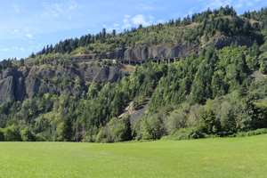
Cape Horn, along with Crown Point in Oregon, forms the western gates of the Gorge. And Cape Horn, like Crown Point, was a major obstacle for early highway development. Via a cliff-hanging viaduct, the Evergreen Highway (SR 14) was completed around this imposing landmark in 1930.
The original roadway still clings to Cape Horn, providing a breathtaking, albeit slow drive. The view of the highway from above is equally breathtaking —and far less nerve-racking than the white-knuckle narrow and twisty drive.
If hiking with children and dogs, it’s possible to bypass these vertigo-inducing ledge tops. Less intimidating viewpoints lie farther along the trail. Now drop into a green glen and follow an old woods road to a field-carpeted hilltop. Cross Strunk Road and continue through meadows bursting with blossoms come spring. A big house once stood here. Several more were planned. Today, it’s just meadow, forest and a grand overlook dedicated to Nancy Russell, who helped preserve this tract.
Russell, who passed away in 2008, was the founder of the Friends of the Gorge and a driving force in the creation of the National Scenic Area.
More visual delights await, so continue hiking heading back into lush forest. Descending, soon reach a spectacular viewpoint framed by windblown firs.
Here above the highway, is the classic Cape Horn view that motorists get. You have it all to yourself.
Trace the landscape east to the Columbia’s sparkling waters surrounding Skamania Island. Beacon Rock juts its basaltic head from an emerald cloak.
Oregon’s lofty Nesmith Point and neighbors yield abruptly to the mighty river.
The trail reaches SR 14 at 3.5 miles where an attractive pedestrian underpass allows safe passage of the busy road. Beyond, the trail’s mood radically changes. The terrain becomes more rugged, the topography more harsh, the tread rockier and more challenging but the scenery is awesome.
The lower half of the trail traverses important wildlife habitat, too. Its cliffs house peregrine falcon nests and its talus slopes are home to threatened Larch Mountain salamanders. To protect these species, the lower half of the loop is closed from Feb. 1 to July 15.
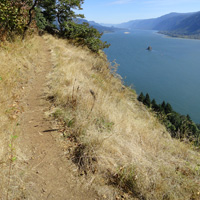
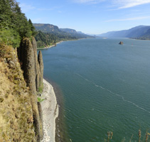
The way now travels across oak-topped basalt bluffs hovering above the Columbia. Views are jaw-dropping. Stare at Phoca Rock protruding out of the river. Lewis and Clark named it for seals from the genus Phoca. Interestingly, they bestowed the name Cape Horn on another cliffy section of the Columbia downriver in Wahkiakum County. A member of Hudson’s Bay Company from Fort Vancouver named this area Cape Heron for its birds. It morphed into Cape Horn years later.
The trail now drops steeply emerging on a bluff teetering right above the river. Railroad tracks below disappear into a long tunnel. Head east along precipitous bluffs lined with contorted oaks. Clamber up and down rugged scree slopes stopping for a jaw-slacking view of Cigar Rock, a narrow vertical basalt bluff hemmed by the cape. The scenery doesn’t get any more stunning.
Pass beneath a waterfall. From here, the trail skirts cliffs and cuts across steep slopes dropping to paved Cape Horn Road. Follow this pastoral country road 1.3 miles back to the trailhead, occasionally turning around to look back up at Cape Horn’s magnificent cliffs.
“This trail is a gem for the Washington side because of its diverse forests, wildflowers and incredible views,” says Rene Tkach, of the Friends of the Columbia Gorge.
Ryan Ojerio of the WTA concurs.
“This trail has many attributes making it an excellent destination; spring wildflowers, fall colors, a few old-growth Douglas-firs, moss-covered talus slopes unique to the Gorge, and a waterfall,” raves Ojerio. “But the Pièce de résistance is the sweeping vista of the Gorge from the Washington side showcasing the dramatic cliff edges of the Gorge in a way that you can’t see it from the Oregon side.”
Hike this trail yourself to see why the Cape Horn Trail has become a Columbia River Gorge Classic.
Getting you on your way
Trip Details
Distance: 7.5 miles roundtrip with 1,350 feet of vertical elevation.
Trailhead Directions: From Vancouver, follow SR 14 east for 26 miles to trailhead at Park and Ride at junction with Salmon Falls Road.
Permits Required: None
Green Trails Maps: Columbia River Gorge West No. 428S
Notes: Dogs permitted on leash; upper half kid-friendly.
Contacts: Columbia Gorge National Scenic Area
www.fs.usda.gov/crgnsa;
(541) 308-1700
Craig Romano is Trails Editor of Outdoors NW and is the author of nine Northwest hiking guidebooks including Day Hiking Columbia River Gorge (The Mountaineers Books), which spotlights 100 hikes on both sides of the river. Visit him at CraigRomano.com.


