NW Trails: Trail Running Ross Lake
Trail Running the Skagit Fjord
Story and Photos by Craig Romano
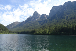
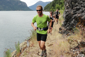
Photo at right: The gang running the trail on the bank of Hozomeen Lake.
Over 20 miles long, barely a mile wide and cradled by craggy glacier and ice-shrouded peaks rising more than a vertical mile above blue-green waters, manmade Ross Lake is surrounded by spectacular natural beauty.
NW Trails is sponsored by:
Located in the northern reaches of the Cascades, Ross Lake was created in the 1940s when Seattle City Light completed Ross Dam on the Skagit River. The damming, in essence, created a magnificient inland fjord.
I’ve hiked along Ross Lake’s shores and to peaks hovering above it to bask in its glory. But to fully appreciate its magnitude, I decided I would run along its 32 miles—from end to end.
I was in the midst of the training for my first 50 mile race—the White River 50 Mile Endurance Run at Mount Rainier later that summer. I was new to ultra-running and needed a confidence builder for my upcoming race. The run along Ross Lake with its nearly 4,000 feet of cumulative vertical elevation gain would fit the bill.
I recruited three experienced ultra-running friends of mine, Alvin Crain, Joe Tompkins, and Shauna Tompkins to hit the trail with me. The three of them had thousands of miles of experienced trail running and racing under their utility belts. Shauna was the first-place woman finisher in White River several times as well as at other ultra-events.
On a beautiful July morning we met at the Ross Dam Trailhead on Highway 20 also known as the North Cascades Highway. We first shuttled a car to Canyon Creek where we would be returning. Loaded with gels, blocks, and electrolyte tablets (plus me with a camera and GPS as I am always writing and recording) we got an early morning warm-up running the one-mile downhill trail to the Ross Lake dock above the dam.
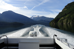
We had arranged for a water taxi pickup and were soon whisked away, zooming across beautiful mountain reflections upon the lake’s placid waters. The scenery was stunning and we hadn’t even begun our epic run
About a half hour later we were docked at the Hozomeen boat ramp on the northern end of Ross Lake, just south of the Canadian border. As the boat pulled away, I realized I was now committed to this run—I had 31 miles to go to the trailhead. Off we went for the Hozomeen Lake Trail where we slowly and steadily began ascending.
Spider webs confirm isolation
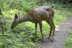
The tread was smooth, perfect for trail running. There wasn’t another human soul on the trail. My head-on collisions with overhanging spider webs confirmed this. Farther into the run, however, I encountered the first of several inquisitive deer. Better deer than bears I thought, as the surrounding North Cascades teem with bruins, even a few grizzlies.
 We made a side trip to Hozomeen Lake hoping to not only hear one of its resident loons (but to also bask in the beauty of the rock spires of Mount Hozomeen hovering above the lake.)
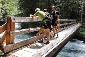
We continued deeper into the wilderness angling behind Little Jackass Mountain, passing Willow Lake and then steeply descending in dark primeval forest. I learned some downhill techniques for averting quad burn and put them to good use on the knee-knocking drop.We crossed thundering Lightening Creek (thank God for the sturdy bridge), encountering two backpackers with faces of disbelief (you’re running how many miles?!). We crossed Lightning Creek once again, checked out the old trapper’s cabin and then started a long hot ascent across the rocky open southern slopes of Desolation Peak. My running partners were way ahead of me. I was in mid-run slump.
Ultra running requires strong mental conditioning as well as physical, and this was the time for mind over matter. After a little walking and much eating and rehydrating—and marveling at spectacular views across Ross Lake from high above—I was ready for the second half of the run.
Another steep descent and a dart over a suspension bridge high above Lightning Creek, and we were now right along the lake. Now through mostly open forest with lots of ups and downs, the scenery along Washington’s manmade fjord kept my mind off of the miles. The trail had been blasted in ledges in spots practically at lake level giving the illusion of running on water.
We crossed many cascading creeks that served as hydration refueling and head-soaking stations.
The trail eventually pulled away from the lake for yet another long uphill slog. Through a uniform forest, it was monotonous. Thoughts of a steak fajita and cold beer after my run kept me going—barely. Cresting 2,500-foot Hidden Hand Pass was a psychological milestone, however, there was still over four miles to go. My energy level was waning, and my running partners tried their darnedest to keep me focused.
As we approached Ruby Creek, the end of the trail run was getting near. I dug into my final reserves for the last mile. An uphill finish made it all the more satisfying. I made it! Despite the run being slow for my companions, the sub nine-hour time it took me did indeed give me the confidence that I could complete the White River.
I did that later that summer, with thoughts of running along Washington’s great inland fjord helping me complete one of the biggest physical challenges I have ever undertaken.
Getting You on Your Way
Trip Details
Distance: 32 miles one way (includes approach to dock)
Ross Lake Trailhead Directions: From Burlington follow SR 20 (North Cascades Highway) for 75 miles east to trailhead.
Ross Lake Water Taxi: Reservation required through Ross Lake Resort, www.rosslakeresort.com.
Permits Required: None for day use
Green Trails Maps needed: Ross Lake No. 16, Diablo Dam No. 48, and Mount Logan No. 49.
Dogs allowed on leash
Contacts
North Cascades National Park complex: www.nps.gov/rola
Craig Romano is Trails Editor of Outdoors NW and is the author of eight Northwest hiking guidebooks including Backpacking Washington (The Mountaineers Books), which includes detailed trail information in this route. Visit him at CraigRomano.com.


