NW Trails: Corral Pass
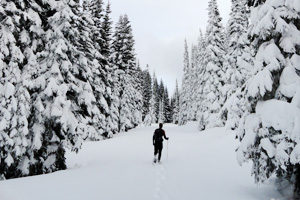
Snowshoeing to the edge of Norse Peak Wilderness near Mount Rainier
Story and Photos by Craig Romano
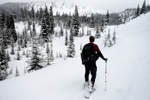
Photo at right: Frosty firs create a winter wonderland.
If you’re looking for a challenging valley-to-ridgeline snowshoeing adventure — and one that is easily accessible and safe from avalanche danger — saddle up for Corral Pass, off Highway 410, about 32 miles from Enumclaw, Wash.
NW Trails is sponsored by:
You’ll get a winter wonderland workout on this trip, climbing 2,800 vertical feet.
If breaking tracks to this high pass on the Cascade Crest is just a tad too much for you to tackle — there is a nice viewpoint along the way that is much easier to reach. But, if you can push on all the way to the Pass, you’ll be rewarded with glimpses of Mount Rainier and a nice all-out panoramic view of the surrounding Norse Peak Wilderness peaks.
While the climb is long and steady, the grade is moderate. Following a Forest Service Road up a thickly timbered shoulder of Castle Mountain, the way crosses no avalanche chutes making it a fairly safe route into the high country. It makes for a good ski route, too, and an excellent destination for backcountry winter camping. The route does see some occasional snowmobile use, but often the way is untracked by machines.
Two trails, both family-friendly
Start up the frozen roadway and soon come to a gate. Here, two trails diverge, making for good easy family-friendly snowshoeing options. The White River Trail takes off directly north for its nearly six-mile journey down the White River Valley. The Forest Trail Loop heads northwest to the Alta Crystal Resort.
For Corral Pass, you want to continue right on the old road and start climbing. En route, look for fresh hoof prints in the snow. During winter and spring, elk are prolific in this valley.
Once the high country snow melts, most of these majestic members of the deer family will return to the sprawling meadows at Corral Pass and surrounding open ridges and basins. But in the winter, they are looking for good browse in the valley’s greenery.
After about .6 miles you’ll reach a good spot for a break or to turn around if not intent on going all the way to the Pass. Here just to the north, climb a couple of hundred feet to a viewpoint of the White River Valley. From this perch, look out at the Crystal Mountain Highway winding up to the ski area base. Locate Slide Mountain and Sun Top across the valley.
Resume climbing, winding up a steep forested ridge. After four uphill miles, round a ridge for unobstructed views of Deep Creek Valley, Mutton Mountain and Dalles Ridge. Soon afterward, come to a high basin tucked beneath open and craggy Castle Mountain. Sporting flowering meadows in the summer, this basin now rolls out a white carpet inviting you to explore by snowshoe.
The Pass is still a few more expendable calories away, but the grade is much easier now. After cresting a small ridge and skirting beneath a crag, traverse a beautiful grove of old growth subalpine fir. At 5.6 miles reach 5,700-foot Corral Pass.
Corral Pass Campground
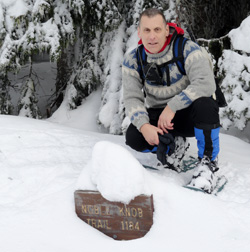
Try to locate the Noble Knob Trail. Its signpost may be sticking out of the snowpack. Walk a short distance farther to a large opening in the forest. It’s the site of the Corral Pass Campground. The kiosk and privy can usually be located sticking out of the thick winter blanket of snow. Perhaps you can locate a picnic table, too. Perhaps not—so lay your insulating foam out on the snow and break out the thermos and refuel. Enjoy views east down into the Greenwater River Valley and south to Castle Mountain and Fifes Peak.
If you have more energy and time is on your side, consider snowshoeing a short way up the open slopes of Castle Mountain. The view of Mount Rainier is excellent from this long craggy peak that was denuded of its forest cover by a fire back around 1900.
Another excellent option for strong snowshoers, or those camping overnight at Corral Pass, is to walk a mile north to Mutton Mountain’s open slopes. From this peak along the Cascade Crest, savor sweeping views to the Olympic Mountains, Mount Stuart and Mount Rainier hovering over the emerald ridges of the Sourdough Mountains. If you packed up skis, enjoy the quick and exhilarating trip back to your vehicle. If snowshoes are your only mode of travel, enjoy the much easier return descending 2,800 well-earned vertical feet.
Getting you on your way
Trip Details
Distance: 11.5 miles roundtrip with 2,800 feet of vertical elevation
Trailhead Directions: From Enumclaw, follow SR 410 for 32 miles turning left (just past Milepost 56) onto FR 7174. Continue .5 miles on FR 7174 to where the road turns north away from cabins. Park here, being sure not to block roads or cabins.
Green Trails Maps: Greenwater No. 238, Lester No. 239 and Mount Rainier Wonderland No. 269S
Notes: When snow level is low, parking is a challenge. Park at power substation (don’t block gate) and walk additional half mile up-road to hike start.
Contacts: Mount Baker-Snoqualmie National Forest; (800) 627-0062; www.fs.usda.gov/mbs
Craig Romano is Trails Editor of OutdoorsNW and is the author of nine Northwest hiking guidebooks including the Winter Hikes of Western Washington deck (The Mountaineers Books), which spotlights 50 snow-free hikes. Visit him at www.CraigRomano.com


