NW Trails: Backpacking Olympic National Park’s Wild Wildcatter Coast

Story and Photos by Craig Romano
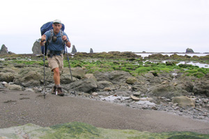
Photo at right: Seastacks and tidepools greet hikers on the approach to Jefferson Cove in Olympic National Park, Wash.
Large wild stretches of coastline in the Lower 48 are about as common as phone booths. Wilderness beaches have all but disappeared in the continental United States. A few pockets still exist in Maine and on barrier islands along the East Coast. On the West Coast, California’s Lost Coast is as wild as it was before the 1849 Gold Rush.
NW Trails is sponsored by:
And here in the Pacific Northwest, Washington’s Olympic Coast remains one of the longest wildest stretches of seashore south of the Canadian border.
50 Rugged Miles of Coastline
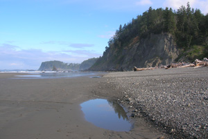
The Olympic Coast harbors nearly 50 miles of rugged and stunning coastline free of development and roads, offering some of the finest beach hiking in America. The entire wilderness coast from the mouth of the Hoh River to Shi Shi Beach bordering the Makah Reservation also makes for some of the best backpacking in the country.
And the southernmost 17 miles, which I like to call the Wildcatter Coast, are exceptionally rugged, offering a true wilderness experience.
On this stretch of Pacific shoreline, clamber over daunting headlands and traverse saturated forests. Wander past secluded coves, sprawling tide pools and magical beaches. Marvel at roving shorebirds harvesting the surf. Awe at crusty rocks decorated in purple and orange by colonies of starfish. Experience amazing sunsets watching a fire-red sun extinguished by a furious ocean disrupted by jagged sea stacks and bulky guano-stained bird-incubating islands. And pass relics of the shattered dreams of oil men (hence Wildcatter) who had hoped to exploit this rugged beauty.
The Wildcatter Coast is shorter but more difficult to hike than the longer Shipwreck Coast from Rialto to Cape Alava to the north. But, you won’t need to secure a limited camping reservation along this stretch, making trip planning easier. However, you still need an overnight permit.
You’ll also need to arrange for a shuttle to do this hike as a one-way. It’s best from south to north, timing the tide for the initial headland rounding and getting the hardest part of the hike—the trudge over Hoh Head—done with first.
Starting in a forest of big cedars and hemlocks, follow the remnants of an old road, leaving Oil City, which was platted with parcels sold to speculators but never developed. Following the Hoh River the trail soon ends on its rocky banks. Now walk toward the coast. The surroundings are ethereal. Abbey Island floats above the mist south, while Destruction Island hovers above the surf farther out to sea.
Reach the beach and turn north immediately rounding imposing cliffs—passable only in low tides. After clambering over some big boulders, reach Jefferson Cove. Then the fun begins with an insanely steep climb via muddy, slippery, and unnerving cables and sand ladders up over massive bulky Hoh Head. Take your time and concentrate; the going is tough. The way is muddy and slippery in places and can be slow going.
You’ll top a 350-foot high point but gain over four times that elevation in countless ups and downs along the way. Cross a few creeks and pass some decent viewpoints out to the crashing sea. Negotiate mud holes capable of swallowing entire civilizations.
At just over six miles, come to good camps on a wooded bluff with fine views out to the ocean. Mosquito Creek lies just below providing drinking water and a terrifying ford in high tides and rainy periods—sometimes not fordable at all. During low tides in the warmer months, however, it is often just an ankle wetter.
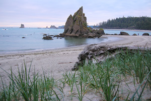
Beyond the creek lies one of the nicest stretches of sandy beach on the Olympic Coast. Savor it. Pass “shark fin” sea stacks and semi-submerged rocks clinging with starfish. Watch pool-probing black oystercatchers, and surf-riding guillemots and scoters. Admire, too, Alexander Island off in the distance.
Near a huge beach-protruding rock, locate a headland trail and take it climbing before dropping steeply to Goodman Creek. Ford the creek, which in winter and high tides may be impossible to cross. Then continue on trail through spruce forest soon coming to Falls Creek and yet another potentially problematic ford. A pretty cascade (hence the name) tumbles just upstream. Climb once again before steeply descending by way of rope and a precarious sand ladder to a beautiful sandy beach.
Toleak Point with its showy sea stacks and offshore natural arch is just a short hike to the north. A favorite destination for many a backpacker, fresh water and plenty of campsites can be found here and all the way to Strawberry Point one mile farther. Beyond, it’s more steep bluffs, fabulous tide pools, and the Giants Graveyard, a flotilla of sea stacks and islands just off the coast. Try to time this section for low tide. A low to medium tide is needed to get by two small headlands just beyond.
Next in line is Scott Bluff, an imposing headland with a jumble of boulders at its base. While it can be rounded in a low tide—it’s rough and not advisable. Take the steep rope-assisted overland trail (not an easy route either) instead continuing to a cove flanked with flowerpot shaped sea stacks. Then locate an overland trail to make a long climb over Taylor Point, which can’t be rounded at all.
Cross a creek near the top of a waterfall before dropping steeply with some aid of sand ladders to Third Beach. Then walk an easy half mile on this gorgeous beach along Strawberry Bay to a trail located near a stream. You can continue beach hiking another half mile toward Teahwit Head if you’d like to look for abandoned equipment once used by wildcatters—or complete your hike by following the trail 1.3 miles to the trailhead completing your adventure.
Getting you on your way
Trip Details
Distance: 17.5 miles one way
Green Trails Maps: La Push No. 163S
Trailhead Directions:
Southern trailhead: From Forks, travel south on US 101 for 15 miles turning right onto Oil City Road. Then proceed for 10.6 miles to trailhead.
Northern trailhead: From Forks follow US 101 north for 2 miles to junction with SR 110. Then proceed west on SR 110 bearing left at 7.7 miles onto La Push Road and continuing 3.8 miles to Third Beach Trailhead.
Notes: Shuttle needed. Route involves headlands that can only be rounded at low tides (carry tide chart), and via steep sand ladders (use caution). Route also involves creek fords dangerous in high tides and periods of high rains. Olympic National Park Wilderness Camping Permits (fee) required. Bear canister required (available at ranger station for rent).
Contacts: Olympic National Park Wilderness Information Center, www.nps.gov/olym
Craig Romano is Trails Editor of OutdoorsNW and is the author and co-author of 12 Northwest hiking guidebooks including Backpacking Washington (The Mountaineers Books), which includes more details on this and other Olympic Coast hikes. Visit him at www.CraigRomano.com


