Profile: Green Trails Maps

Celebrating 40 years of outdoor adventure!
By Diane Rudholm
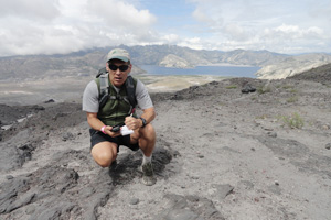
Photo at right: Craig Romano maps Mount St. Helens near Loowit Falls for Green Trails Maps. Photo courtesy of Craig Romano
Do you like maps? Who doesn’t? If you’re like me, you probably have a few Green Trails maps in the nooks and crannies of your home, car and office just in case the explorer bug strikes.
Or, maybe you’re more like mountain-bike guidebook author John Zilly who has a lot more than a few.
“I literally have hundreds of Green Trails’ maps in my office,” says Zilly. “I love (them). I’ve spent so much time staring at them, imagining cool trips.”
Quality that stands the test of time
Green Trails Maps is observing its 40th anniversary this year with new maps, a new website and a new overall look for its brand. What hasn’t changed is the grade-A quality that adventurers have come to expect and to rely on.
“When I started writing mountain bike guidebooks for the Northwest … I always used Green Trails maps if I could while researching,” says Zilly, a Seattle native. “They were the clearest and most accurate. They still are!”
Late founder Walt Locke started Green Trails Maps in 1973 when he saw an unmet need for quality hiking maps. Once a production coordinator for Boeing’s lunar lander and a member of the 747’s development team, Locke had a knack for spatial reasoning that proved to be perfect for mapping trails with a renowned level of accuracy.
In 1993, Locke handed the reigns over to current owner and president of Green Trails Maps Alan Coburn who continues to run the company with a reverence for its founder. When big decisions are on the drawing board, Coburn says that he and his team ask, “What Would Walt Do?”
Maps for adventurers of all ages
Green Trails Maps publishes more than 140 topographic recreation maps for wild places in the U.S., including scores of mountain, beach and desert areas in Washington, Oregon and British Columbia.
It also produces special MapPacks—offered on its website—that cover locations in the Mountaineer’s Hikes with Children guidebooks. These maps are produced in a small size that is easy for children to manage, making them ideal for young hikers, birdwatchers and students.
“I started using Green Trails Maps (as a youth) back in the late 1970s,” says Zilly. “My family would go on lots of hikes and extended backpacking trips. We’d always use a Green Trails map if one was available.”
Nowadays, if you’re in an outdoor recreation store in the Northwest, it’s likely that you’ll find some of Green Trails Maps’ stellar creations. You can also check the company out online at www.GreenTrailsMaps.com
Diane Rudholm is the managing editor and social media manager of OutdoorsNW magazine.


